
Traditional owners
This land has been cared for by the Wurundjeri for at least 60,000 thousand years. Over this time they developed and maintained a deep and unbreakable cultural connection to their traditional Country. Over this immense time period the land has changed with the comings and goings of geological epochs and the rising and falling of sea levels, as recorded in the Wurundjeri Dreamtime stories.
The site of Indi Footscray would have once been far inland from the coast. Its current position near the banks of the Maribyrnong river was created with the dramatic rise in sea level that formed Port Phillip Bay and the Birrarung and Maribyrnong rivers systems.¹
The Wurundjeri were witness to this event. Their oral memory recounts the creation of these water courses in a number of Dreamtime stories. A variation of the version of the story recounted by elder Billibellary to early colonists in the 19th century is included on an interpretation panel at the Indi Footscray site. Another versions reads:
Once the water of the Yarra was locked in the mountains. This great expanse of water was called Moorool, or Great Water. It was so large that the Woiwurong had little hunting ground. This was in contrast to the Wothowurongs and the Bunurongs, whose hunting ground was the lovely flat which is now Port Phillip Bay.
*The headman of the tribe was Barwool...who resolved to free the land. He cut a channel up the valley with his stone axe. But he stopped by Baw Baw, the Mountain. He decided to go northwards, but was stopped by Donna Bunag and his brothers. Then he went westwards, and cut through the hills to Warrandyte. Then he met Yan-yan, another Woiwurong, who was busily engaged in cutting a chanel for the Plenty River in order to drain Morang, the place where he lived. The joined forces and the waters of the Mootool and Morang became Moo-rool-bark, the place where the wide waters were. Between the Darebin and the Merri Creeks they cut a narrow, twisting track, looking for softer ground. At last they reached Port Phillip. The waters of Morrol and Morang rushed out. The country of the Woiwurung was freed from water, but Port Phillip was inundated.*²
Amongst this changing landscape, the Wurundjeri people's dynamic connection to country remained steadfast. Within a rich cultural and social life, specific species of plants were used for medical and culinary uses and plants along the water courses were used as food resources.
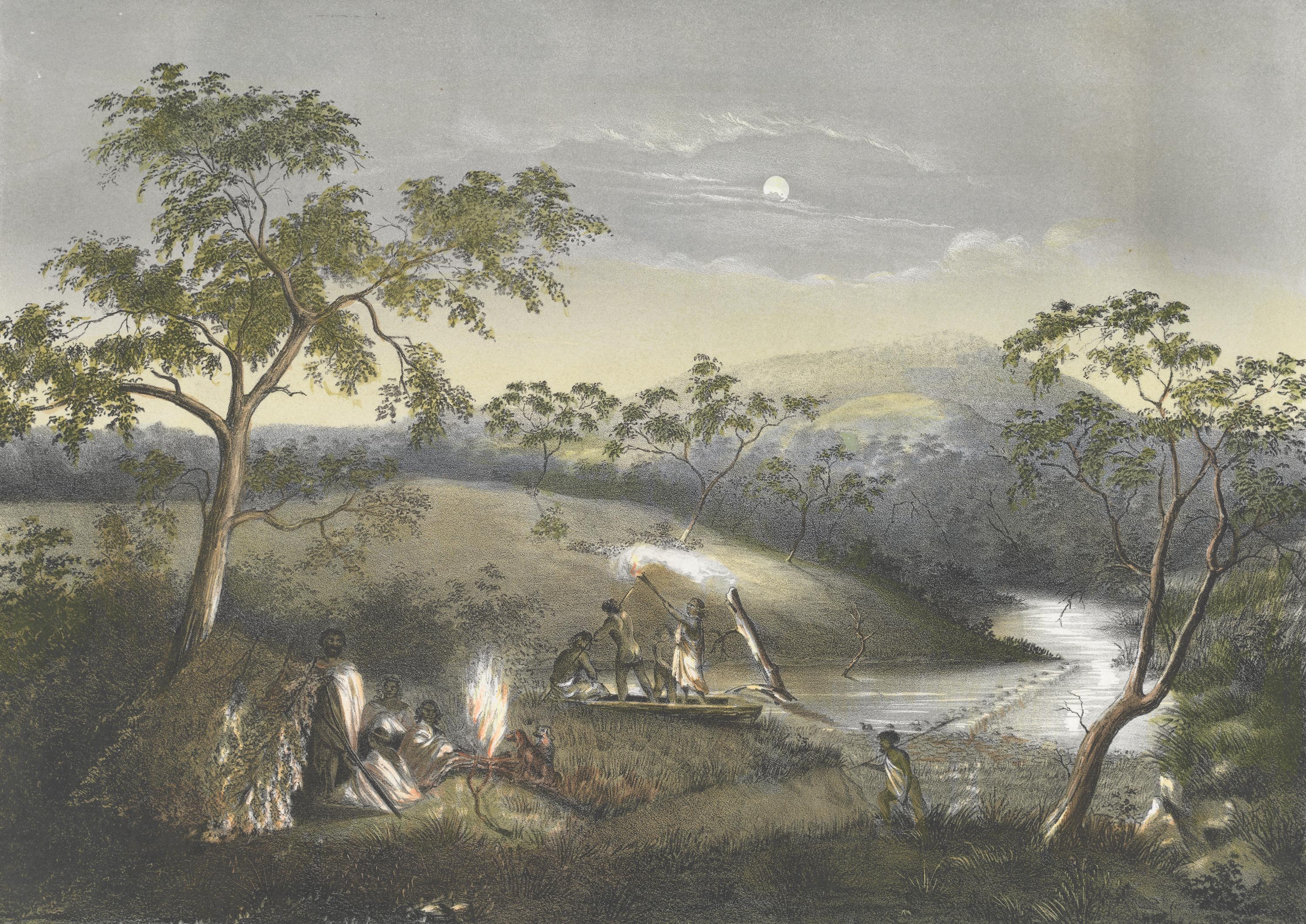
Figure 1 – Merri Creek, Plenty Ranges 1864. Colour lithograph.
Source: Courtesy of the National Gallery of Victoria, Melbourne.
Source: Courtesy of the National Gallery of Victoria, Melbourne.
Impressions of the landscape
Closer to the time of European people’s arrival, much of the volcanic plains west of Melbourne were virtually treeless. This was a product of the practice of regular firing of the grasslands by the Wurundjeri. This practice has been scientifically proven to reduce the density of plant growth, encourage new species and make it easier for paths to be maintained – this was all knowledge held by the Wurundjeri people.⁴
European people encountering the land for the first time exclaimed at this distinctive lack of trees. British surveyor Charles Grimes noted there were ‘no trees for many miles’, while John Batman is recorded as described the land as having ‘[kangaroo grass] to a height above his knees’.⁵ Explorer Gellibrand described the land as:
*very rich and consists of a succession of gentle hills and dales and the first view of the salt water and its Windings is beautiful beyond description… [consisting] of open plains with a thin coat of grass and exposed to the cold winds.*⁶
Another European, Thomas McCombie, described the area as consisting of:
*…extensive plains…having a sprinkling of trees scattered here and there in groups after the manner of a gentleman’s park in England. The country however is irregular, presenting at times a long succession of green mounds.*⁷
In the last 150 years, these vast tracts of grassland have been almost entirely lost, removed for development or through the effects of industry and agriculture. The indigenous vegetation is ‘now isolated in small pockets which contains a significant proportion of Victoria’s endangered species.⁸ Regardless, the Wurundjeri Woi Wurrung people retain a strong connection to their traditional country in the Maribyrnong area. Many built heritage sites across Footscray are significant to their community as sites of activism and community building.⁹
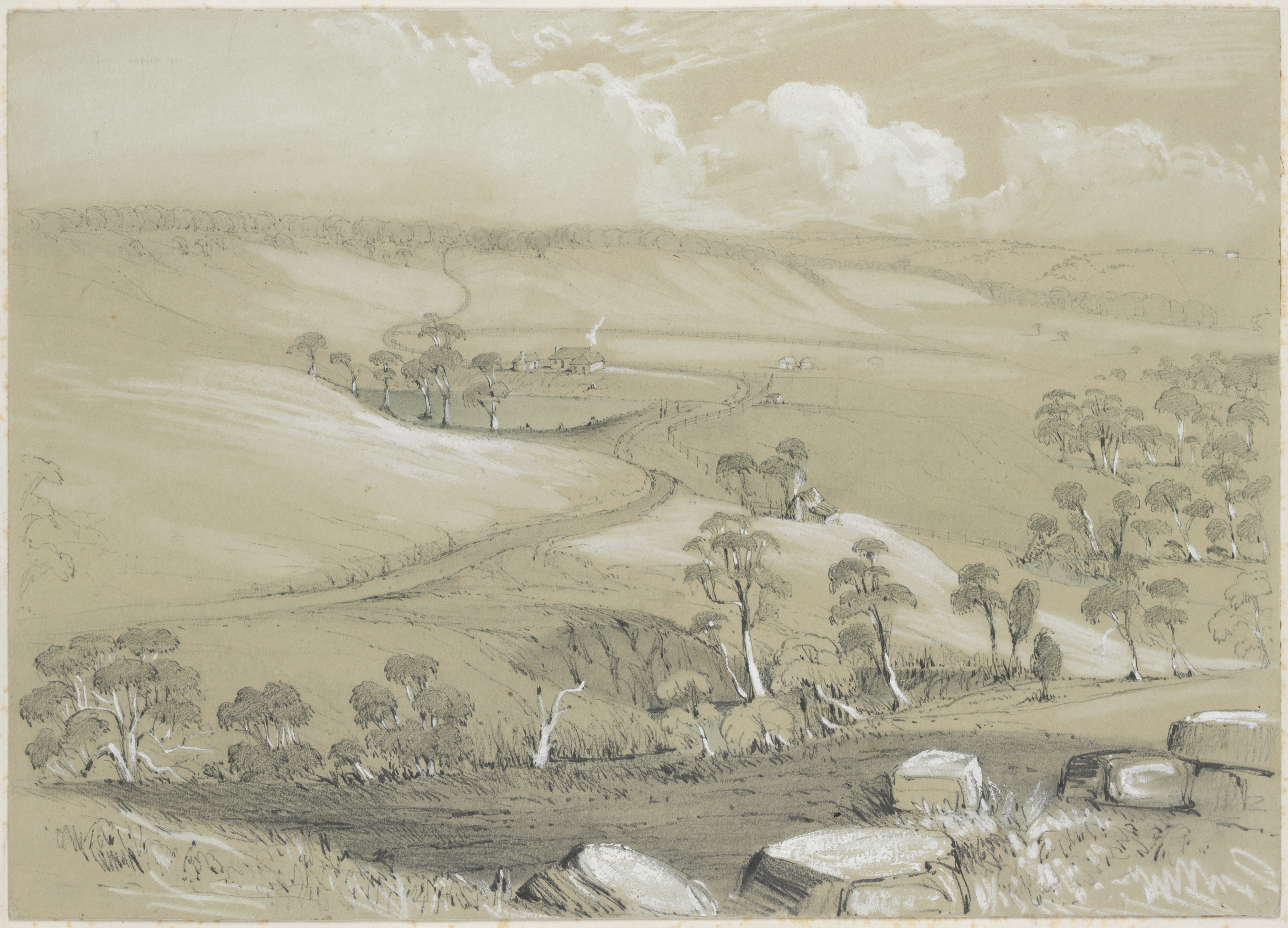
Figure 2 – c. 1845 drawing of the Saltwater River (now Maribyrnong River) by George Alexander Gilbert.
Source: Courtesy of the State Library of Victoria Online Picture Collection, PCLTFBOX GILBERT 1, H6639.
Source: Courtesy of the State Library of Victoria Online Picture Collection, PCLTFBOX GILBERT 1, H6639.
Footscray Railway Station
A village was surveyed at Footscray in 1848, formalising what had been an informal crossing point based around a punt over the river that had been established years earlier. The punt provided one of the many connections between Melbourne city, and the vast Western district beyond the outer suburbs of Melbourne.¹⁰
As the village grew and grew, the original Footscray Station opened on what is now the subject site in January 1859, 11 years after the village of Footscray was first surveyed.¹¹ For more than forty years, the subject site was the main entry and exit point for local residents travelling to and from the city of Melbourne. The station building sat on the north side of the tracks, with only a small shelter to the south. The main access to the station was off Napier Street while there was a tree lined path leading to the station from Nicholson Street. A cinder track ran parallel to the railway and connected to a timber footbridge which provided access from Irving Street. This path is now interpreted in the landscaped area around the Moreton Bay Fig at Indi Footscray.
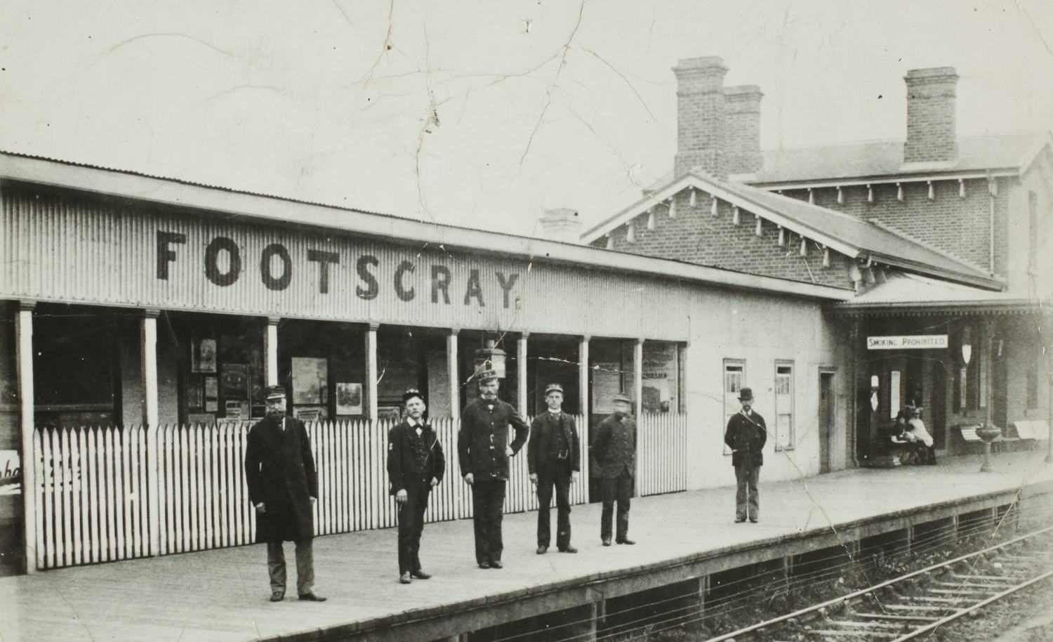
The station building had much in common with what would become known as the Carlsruhe style of railway buildings. This style was used by the Victorian Railway Commission for many stations in the 1850s and 1860s and takes its name from a station building in central Victoria. As evident at Figure 3, the original station building consisted of a two-storey gable roofed section connected to a perpendicular single storey gabled roofed section. It was constructed of face brick with a slate clad roof and three large brick chimneys. The underside of the eaves had large and distinctive consoles.
Figure 3 – Footscray Railway Station, c.1900.
Source: Picture Victoria, Maribyrnong Library, ID 5114, courtesy of the Footscray Historical Society.
Source: Picture Victoria, Maribyrnong Library, ID 5114, courtesy of the Footscray Historical Society.
Footscray Railway Reserve
In 1900, the original Footscray Station was decommissioned and the new station buildings were constructed at their current site off Irving Street.¹² The vacant land which contained the original station building and grounds, an area of about two acres, was leased to the Footscray City Council. And subsequently, the Council established a public reserve on the site.¹³ The reserve had two halves, split in two by McNab Avenue, which was constructed to provide access to the new station constructed at the current site off Irving Street.¹⁴
The existing band rotunda in the railway reserve was moved to the site in 1904 and formed the centrepiece of the reserve from this time.¹⁵ Further developments in the railway reserve occurred shortly after. The Footscray City Bowling Club (FCBC) was initially based on the grounds of the Footscray Town Hall but on the demolition of the original railway station, the club moved to the newly vacant site in the reserve on McNab Avenue.¹⁶
The land on McNab Avenue was leased to the club from the Railway Commissioners. The green was installed by J W Horsfall, who was responsible for the prominent bowling green at Middle Park. It was of a standard high enough to host interstate matches.¹⁷ With a popular bowling club, band rotunda, paths and landscaped areas for recreation, the railway reserve became a central site of leisure in central Footscray in the early 20th century. Demonstrating the importance of the site, a statue of prominent local philanthropist and industrialist James Cuming was unveiled in the park after his death in 1911. The statue was relocated to Yarraville Gardens in the late 20th century.¹⁸
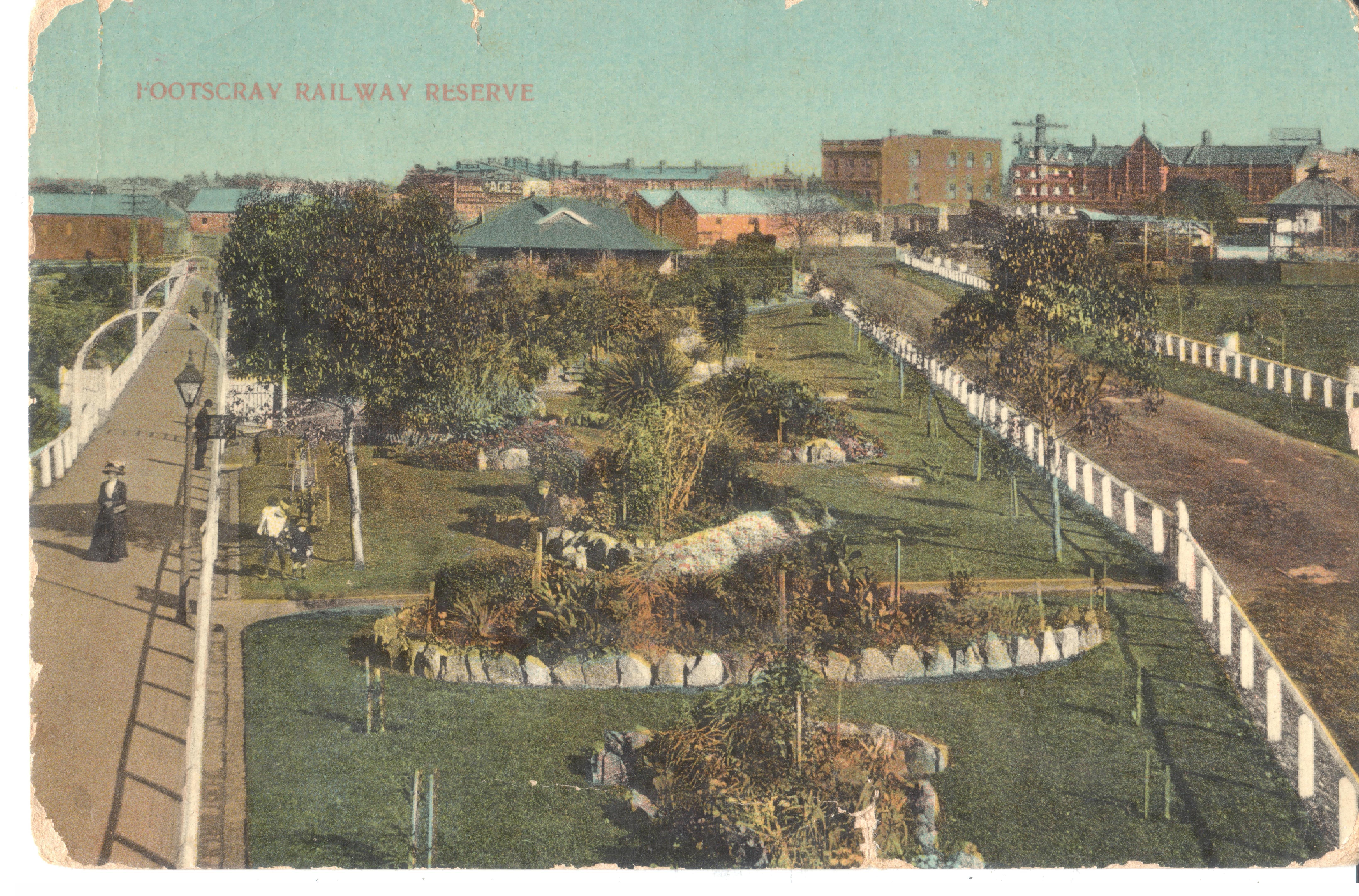
Figure 4 – Footscray Railway Reserve, c.1911
Source: Courtesy of the Footscray Historical Society.
Source: Courtesy of the Footscray Historical Society.
Footscray City Bowling Club
A 50 second clip held by the Australian Centre for the Moving Image (ACMI) shows the reserve in action in 1911. Gentlemen leisurely play a game of bowls on the manicured grounds of the Footscray City Bowling Club, which is shown edged in hedges and shrubs, providing a private oasis for club members.
The footage also provides a crisp image of the Bowling Club headquarters building, of which few photos survive. The building is shown with a gambrel roof which extends to a wide verandah supported on slender columns, providing shade for club members in the hotter months. A central entrance on the north elevation was flanked by casement windows. In the background, children can be seen playing on swings to the north side of the reserve near the current gazebo.
The current site played host to many games of bowling and was the nexus of a close amateur sporting community for decades, at least into the early 1970s.¹⁹ The club went into a decline in the late 20th century and, after sitting neglected for years with a green overrun with weeds, the club house burnt down in 1999.²⁰
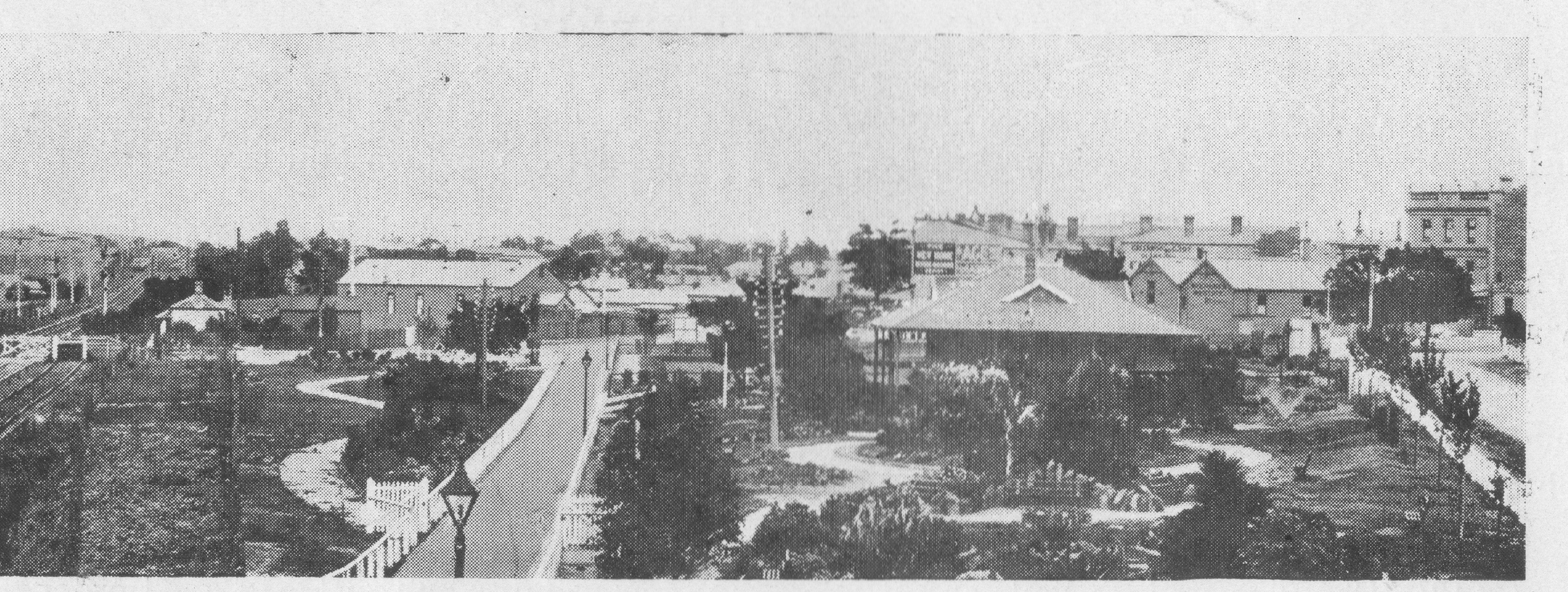
Figure 5 – Footscray City Bowling Club building and landscaped reserve, in an undated photograph, likely c.1910. The location of the original station building is to the left of image.
Source: Courtesy of the Footscray Historical Society.
Source: Courtesy of the Footscray Historical Society.
Multicultural Footscray
The City of Maribyrnong has long-held a reputation as a vibrant and resilient multicultural community that is welcoming to people new to Australia.²² As of 2011, the community represents 147 overseas countries, with 40% of residents born outside Australia and at that time 119 languages are spoken in Maribyrnong.²³
Within Maribyrnong, Footscray specifically is ‘an ethnically diverse suburb...diverse both in numbers of people born overseas and the extraordinary range of nation states from which they have migrated’.²⁴ Studies have defined Footscray as ‘a place that embraces cultural diversity, where everyday diversity has come to be a defining feature’.²⁵
Since the beginning of European colonisation of Melbourne in the early 1800s, there has been a constant flow of migrants from all over the world to the area we now know as the City of Maribyrnong, and Footscray in particular.²⁶ Many of the people arriving from 1950s-1980s were refugees seeking asylum from war and its aftermaths. The 1950s-1960s saw a significant wave of post-war migration from Europe to the area.²⁷
In contrast to the migration patterns of Melbourne as a whole, this post-war migration to Footscray saw a greater breadth of cultural diversity. In the 1950s, there were more immigrants from eastern and southern Europe in Footscray than from Britain.²⁸ Enduring figures that relate to this aspect of Footscray’s cultural diversity include the long running Italian family business T Cavalarro and Sons, who continue to attract patrons to their store on Hopkins Street for cannoli and strong black coffee to this day.
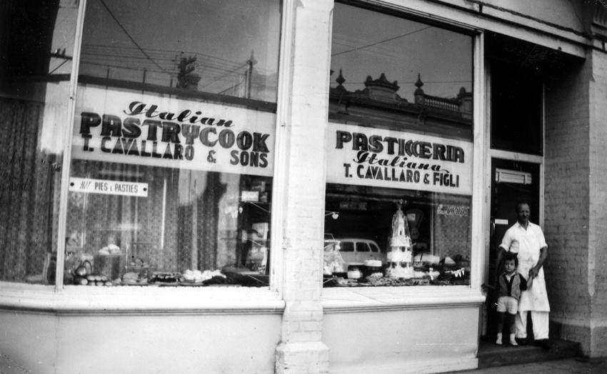
Figure 7 – T Cavallaro & Sons, c1957-58.
Source: Reproduced with permission from Tony Cavallero and the Cavallero family.
Multicultural community
After 1975, Asian communities settled in and around Footscray. Now the City of Maribyrnong’s Vietnamese community remains a cultural group with strong associations with the area.²⁹ The Vietnamese diaspora still influences the contemporary blend of cultures but ‘so too do migrants from several African countries who have developed a thriving commercial and social centre in Footscray’.³⁰
The Vietnamese community has a physical representation in the Little Saigon Welcome Arch, designed by architects McBride, Charles, Ryan (MCR) and constructed in 2006. The arch stands at the corner of Leeds and Hopkins Street and depicts symbols that are significant to the Vietnamese community including: ‘a pair of cranes, the shell of the turtle, the bronze drum, the boat and the egg’.
As described by the designers, the arch is ‘evocative of the Vietnamese community’s history, a memorable symbol of thanks and friendship, and above all, a lasting monument to this community’s success’.³
This history of immigration and cultural diversity has imbued:
“a strong collective memory of Footscray as a suburb of migration and of ethnic diversity” – “a city shaped by successive waves of immigration”.
This experience has created a place that many residents view as ‘constructed as a place in which diversity is regarded as normative and protective’.³³
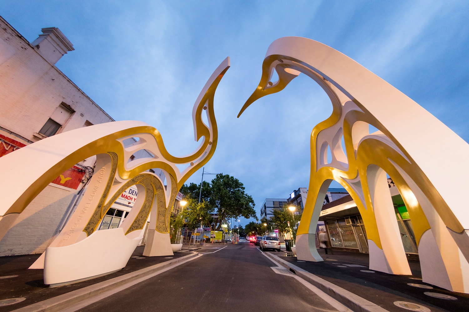
Figure 8 – The Little Saigon Welcome Arch, constructed 2006 to a design by McBride Charles Ryan Architects.
Source: Reproduced with permission from Gollings Photography Pty Ltd.
Source: Reproduced with permission from Gollings Photography Pty Ltd.